Drainage FAQ
1. What is the purpose of the Lakes within Legends Ranch?
The three lakes within Legends Ranch are both an amenity feature for the community and provide detention capacity for the drainage system. The lakes were designed to hold a static water elevation, which act as the amenity portion of the Lakes and does not account for any of the detention capacity. The detention capacity is calculated above the normal water surface elevation to the top of bank. During rain events, as the lakes collect water and the lake levels rise, water overflows into culverts which drain into the Central Drainage Channel.
2. Who is responsible for maintenance of the Lakes within Legends Ranch?
The three lakes are designed to hold water as an amenity feature for the community. The detention capacity is calculated above the normal water surface elevation. It is the responsibility of the Legends Ranch POA to clean/maintain the amenity feature of the lakes.
3. Where does the storm water drain from Legends Ranch?
The storm system within Legends Ranch include the streets, storm inlets, storm sewers and the detention portion of the three Lakes. The western portion of the Legends Ranch storm system, west of Legends Ridge Drive drain into the three Lakes, which drains into the Central Drainage Channel located immediately south of the Legends Ranch subdivision. The eastern portion of the Legends Ranch storm system, east of Legends Ridge Drive as well as The Enclave subdivision do not drain into the Lakes but drain directly into the Central Drainage Channel.
The Central Drainage Channel flows east into the Central Detention Pond located east of Birnham Woods Drive. This pond is drained via a storm water pump station located at the east end of the detention pond that ultimately flows into Stokes Gully and Woodsons Gully south of the Grand Parkway.
The Central Drainage Channel and Pump Station is shared between Montgomery County MUD No. 88, Montgomery County MUD No. 89 and Spring Creek UD and managed by Spring Creek UD.
4. How does the storm water pump station function?
The Central Detention Pond is 15 feet deep and provides approximately 443 acre-feet of detention volume and designed to contain a 100-year frequency storm event with a minimum of 1 foot of freeboard. The storm water pump station includes five pumps with a total capacity of 200,000 gallons per minute or 445 cfs. The detention pond also includes an emergency overflow weir designed to outflow events greater than the 25-year frequency storm event. The storm water pump station has an emergency generator sized to operate two of the five pumps, with the emergency scenario relying on the overflow weir.
The storm water pump station does not pump water directly for the three lakes within Legends Ranch nor do the pumps directly affect the street drainage. The lakes are designed to hold water at a constant water level as an amenity feature. During rain events, as the lakes collect water and the water levels rise, water overflows into culverts which drain into the Central Drainage Channel and ultimately pumped into Woodsons Gully.
5. Why may the water backup in the streets?
The storm sewer system within the District was designed to meet Montgomery County drainage requirements. As a general rule of thumb, the storm sewer system was designed to handle approximately 1 inch/hour of rainfall intensity. In the event that rainfall intensity exceeds the capacity of the storm sewer system, water may begin to rise in the streets. The streets themselves are a part of the drainage system and are designed to hold 12-18 inches of water as part of the capacity of the system. As soon as the rainfall intensity weakens, water in the streets will quickly begin to recede.
MUD FAQ
1. What is the MUD?
Montgomery County Municipal Utility District No. 89 (the “MUD”) is a political subdivision of the State of Texas, similar to the City of Houston (the “City”) and Montgomery County. It has limited governmental functions, including those related to the provision of water, wastewater, drainage services, and solid waste collection. The MUD is not within the city limits of any city, but it is in the extraterritorial jurisdiction of Houston. The MUD includes the entirety of the Legends Ranch development. The day to day operations of the MUD, including services and billing, are provided by its contractor, Municipal Operating Consultants, Inc. (“MOC”).
2. How was it created?
The MUD was created by order of the State agency known as the Texas Commission on Environmental Quality (the “TCEQ”) in 2002. The City consented to the creation of the MUD, and has not been involved in the governance of the MUD. The TCEQ continues to exercise oversight regarding the MUD’s water and wastewater services, and MUD facilities must be designed to City standards.
3. How is the MUD governed?
The MUD is governed by a five-member Board of Directors that serves staggered four-year terms. The MUD holds an election for either two or three of its positions in May of each even-numbered year. To serve, a person must be eligible to vote in Texas (e.g., a US citizen), and either reside in the MUD or own real property in the MUD. All five MUD directors are residents and taxpayers of the MUD.
4. What does the MUD do, and not do?
The MUD provides retail water and wastewater services within its boundaries. The MUD’s water supply and wastewater treatment are provided by plants owned and operated by the MUD, although the MUD shares ownership of some water facilities with neighboring Montgomery County Municipal Utility District No. 88 and Spring Creek Utility District. The MUD also provides for the storm water drainage of the MUD, within the boundaries of the MUD. The MUD contracts for garbage pickup for single family residences within the MUD, and does not charge separately for that service. The MUD does not maintain the roads or landscaping.
5. How does the MUD pay its way?
The MUD charges users for water and wastewater services, pursuant to a Rate Order adopted by the Board and amended from time to time. The MUD also levies a debt service tax to pay its bonded indebtedness, and a maintenance tax to help with operations. The MUD is responsible for contracting for solid waste collection, but does not charge a separate fee for that service, which is paid for out of other revenues of the MUD.
6. What is the MUD’s tax rate?
The MUD levies a property tax on all taxable property in the MUD, which may change from year to year. Taxes for 2025 are currently $0.555 per $100 of taxable value. The tax consists of $0.335 for debt service, and $0.220 for maintenance. 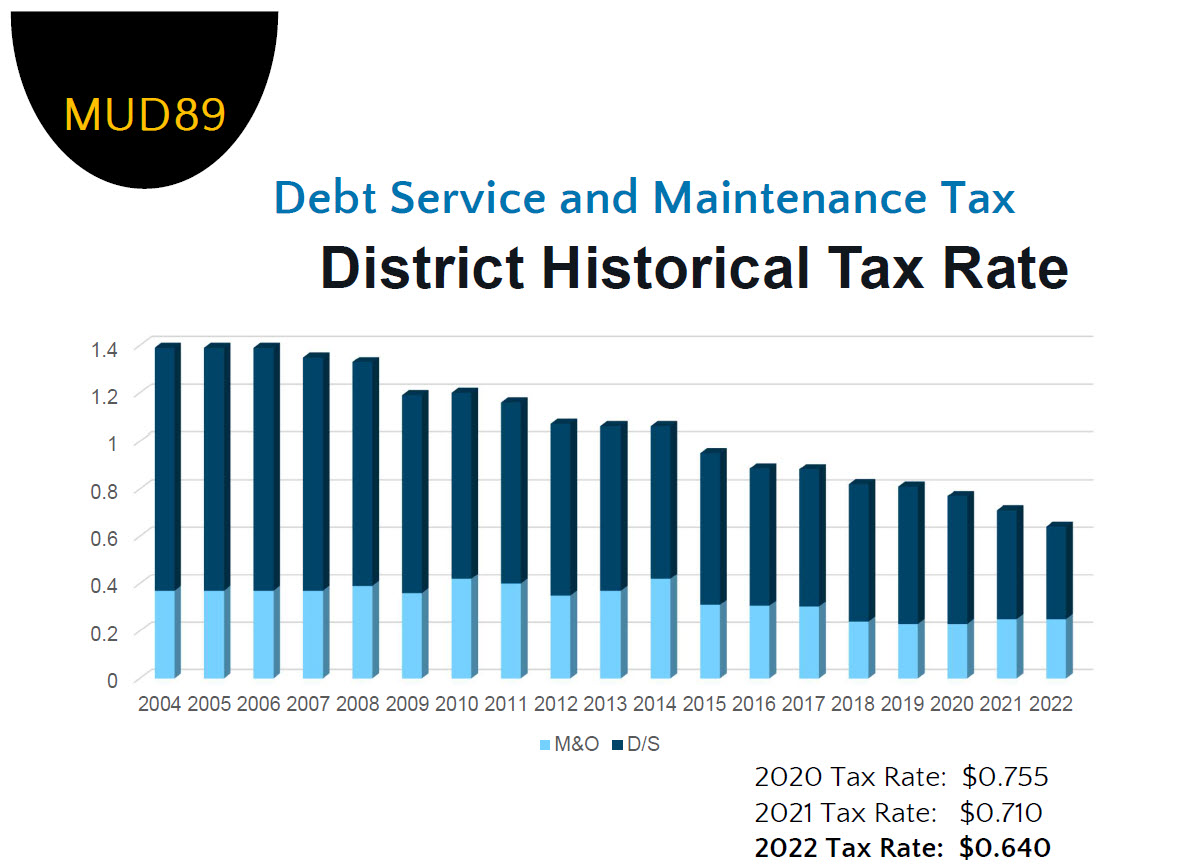
In addition, on February 13, 2026, the MUD adopted a Resolution Concerning Exemptions from Taxation, which provides for the exemption from ad valorem taxation of $40,000 of the appraised value of residence homesteads of individuals who are disabled or are sixty-five years of age or older and 5% of the appraised value (but not less than $5,000) of the residence homesteads of married or unmarried adults, including ones living alone, but rejects any exemptions for travel trailers, which may change from year to year.
7. What is the MUD’s bonded indebtedness?
The MUD owes $16,320,000 in bonded indebtedness. The MUD continues to pay down this debt, and has taken advantage of lower interest rates when possible to refinance the debt from time to time. Outstanding bonds will be retired in 2040. The bonds were approved at an election held at the inception of the MUD.
8. What makes up my water bill?
Customers within the MUD pay the MUD for water and wastewater services. In addition, customers are required to pay regulatory charges imposed on the MUD and its users by the San Jacinto River Authority (“SJRA”) and the Lone Star Groundwater Conservation District (“LSGCD”). The charges are a “pumpage fee” for every 1,000 gallons of water the MUD pumps from its wells. Currently, the pumpage fee imposed by the LSGCD is $0.085 per 1,000 gallons and the pumpage fee imposed by the SJRA is $2.51 per 1,000 gallons, for a combined total of $2.595 per 1,000 gallons. The MUD charges customers the following rates per month: (i) a base fee of $5.50 which institutes the first 3,000 gallons usage; (ii) $1.75 per 1,000 for usage between 3,001 gallons and 6,000 gallons; (iii) $2.00 per 1,000 for usage between 6,001 gallons and 10,000 gallons ; (iv) $2.25 per 1,000 for usage between 10,001 gallons and 15,000 gallons; and (v) $5.00 per 1,000 for usage over 15,001 gallons. The pumpage fee rates imposed by the SJRA and LSGCD are set at the discretion of those governmental entities, and not the MUD, and are subject to change.
9. What is the MUD’s relationship with the City of Houston?
The MUD is entirely separate from the City of Houston, and Montgomery County. The City could annex and dissolve the MUD at any time, but would have to assume all the MUD debt, so annexation any time soon is very unlikely.
10. Does the MUD maintain the roads?
The MUD does not have the power or funds to maintain the roads in the MUD. Occasionally, the MUD will repair or maintain the drainage system that is within the right of way, on a limited basis. The private roads within the community are the responsibility of the homeowners’ association.
11. How can I contact the MUD?
If you have questions about your bill or service related issues, call the MUD’s operator, MOC, at (281) 367-5511. Any other questions, including inquiries relating to the Board of Directors, can be directed to the MUD’s attorney, Allen Boone Humphries Robinson LLP, at (713) 800-8688. Please take a moment to visit the District’s website at https://www.mcmud89.com.
Water FAQ
2023 Water Supply FAQ
1. Do we have an unlimited supply of water?
No. The District is dependent on the aquifers we produce our water from. Recent tests show significant water level depletion. As a MUD, our top priority is to maintain flow rates at each of our water wells while ensuring the water table in the aquifer is there for the long-term. If either fall short, our long-term supply of water will be at risk.
2. Where does our water come from?
The Districts water is produced from groundwater. The Districts produce water from three water wells located at two Water Plant sites. Water Well No. 1 is located at Water Plant No. 1 and pumps water from the Evangline Aquifer (~ 1070’ deep). Water Well Nos. 2 & 3 are located at Water Plant No. 2. Water Well No. 2 also pumps from the Evangeline Aquifer (~1050’ deep). Water Well No. 3 pumps from the Jasper Aquifer (~ 1640’ deep).
3. How much does it cost the District to produce 1,000 gallons of water?
The District’s cost to pump water from their water wells is approximately $2.00 per 1,000 gallons.
In addition, the San Jacinto River Authority (SJRA) charges a groundwater pumpage fee of $2.99 per 1,000 gallons (as of September 2022).
4. What is the life span of a water well?
Water well equipment is estimated to last approximately 50 years with regular maintenance and reworking of the well every 7-10 years. One external factor is the condition of the groundwater aquifer. We monitor water table height and amount of depletion. Well data shows that the many years of pumping water across the Houston area has depleted our nearby groundwater aquifers. Making matters worse is that the water table has fallen more than customary due to the recent drought conditions in 2022 and 2023.
5. How often are the water wells tested?
Water wells are typically tested twice per year at a minimum. It’s typical to run tests once in early fall to check the condition of the pump and motor and aquifer levels after the stress of the summer month water demands, and again in the spring, after the winter months and ahead of the upcoming summer. It’s typical for aquifer levels to decrease after summer months and rebound after winter months, but historically over time, the aquifer levels have continued to decline. The District may test more frequently due to other factors such as the drought conditions or water well age.
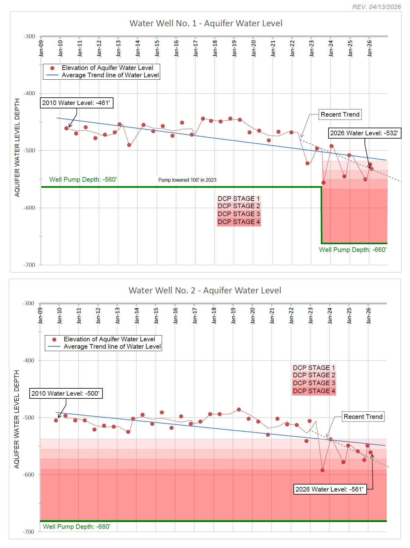
6. What is the current condition of our water wells?
Water Well #1: Constructed in 2003. Last reworked in 2017. The static water level has decreased approximately 125 feet since November 2017. The District recently lowered the pump level 100’ due to the decline in the static water elevation.
Water Well #2: Constructed in 2006. Last reworked in May 2023. The static water level has decreased approximately 107 feet since November 2017.
Water Well #3: Constructed in 2013. Due for a rework in the next 1-2 years. The static water level in the Jasper Aquifer has not seen the same impact as the Evangeline Aquifer. The static water level has decreased approximately 49 feet since November 2017.
7. How many customers does the water system serve?
The District’s water plants are operated by Montgomery County MUD No. 89; however, the facilities are shared with Montgomery County MUD No. 88 and Spring Creek Utility District. MCMUD No. 89 has approximately 1,675 ultimate connections. The system as a whole (including MCMUD No. 89) has approximately 4,057 ultimate connections, under normal operations.
8. Do droughts affect the water supply?
Yes, droughts can drop the water table lower than is customary for a number of reasons.
(1) Recharge of the aquifer is affected when there is no rain to recharge.
(2) Customers tend to irrigate more due to the lack of rain during a drought.
9. How does an aquifer recharge?
Aquifers can recharge through natural processes such as precipitation infiltration, natural recharge from lakes/rivers, or vertical and lateral subsurface migration due to compaction; or via manmade processes such as an artificial recharge well to inject water from the surface into an aquifer.
10. What is the purpose of the drought contingency plan?
To decrease the stress on our water wells and aquifers by limiting irrigation water consumption to help ensure water is available for domestic use.
11. Why does the water sometimes have a sulfur smell?
Water Well No. 3 produces water from the Jasper Aquifer. The Jasper Aquifer in this area has small traces of Hydrogen-Sulfide (H2S) which sometimes causes a rotten egg smell. The water is safe to consume, but may have an odor at times. In order to help combat the smell, the District typically aerates the water to release the H2S gases and mixes the water with the water well pulling from the Evangline Aquifer.
12. How does the District promote Water Conservation?
The District is an active member of the Water Smart program, providing public awareness for water conservation. The District posts frequent water conservation tips on the website. www.mcmud89.com
13. What can we do to ensure we have potable water in the future and protect the longevity of the current water wells?
i. Surface Water: The MUD has entered into an agreement with the SJRA whereby a pipeline will be constructed for the SJRA to provide surface water to the MUD, MCMUD No. 88 and Spring Creek UD. This will help extend the life of the MUDs water wells & aquifer by reducing the demand on groundwater. The MUD is currently designing the project and once designed, the project will take several years to complete. (Updated June 2026.)
ii. Reduction irrigation water use: The District promotes water conservation through irrigation through a smart irrigation controller rebate program which can be connected to our local weather station. More information regarding the rebate program can be found on the District’s website. www.mcmud89.com.
iii. Reclaimed Water Use: Another future consideration is using reclaimed water for irrigation use. Reclaimed water goes through an additional treatment process at the District’s wastewater treatment plant, which is safe to use for irrigation, but is not approved for human consumption. Use of reclaimed water for irrigation would reduce the demand of potable water for irrigation.
14. How much does it cost to build a municipal water plant?
There are many factors that go into the cost of constructing a water plant. Construction of a new water plant with a water well could cost upwards of $7,500,000 but is dependent on various factor.
15. What role does the San Jacinto River Authority (“SJRA”) play in providing surface water?
MCMUD No. 89 is a part of the SJRA’s groundwater reduction plan (“GRP”). Previously, there were conversion requirements to convert the MUDs in Montgomery County to use surface water in order to reduce the consumption of groundwater due to subsidence from over pumping of the aquifers and the decline of static water levels. While the District does not currently receive surface water from the SJRA, we were required to be a part of a GRP, and the GRP as a whole would comply with the surface water conversion goals set forth by the Lone Star Groundwater Conservation District. Had we not been a part of the SJRA’s GRP, we would have needed to find a way to hit the surface water conversion goals on our own.
More information on the SJRA can be found at: www.sjra.net
16. What is the Lone Star Ground Water Conservation District (“LSGCD”)?
The LSGCD was created by the Texas Legislature in 2001 in order to manage and conserve Montgomery County’s groundwater supplies. The LSGCD reviews and issues groundwater pumpage permits to each MUD to regulate the amount of water being drawn for the aquifers each year.
More information on the LSGCD can be found at: www.lonestargcd.org
17. Why is the District implementing the Drought Contingency Plan (DCP)?
Due to the ongoing drought conditions and increased water usage, our water well production continues to increase year over year. Over the years, we have seen continued decline in the water levels in the aquifer.
The graph shows the trending decline in the aquifer’s water level for Water Well Nos. 1 & 2 (both Evangeline Aquifer). Up until about 2022, the water levels in the aquifer had remained fairly constant, but since 2022, the levels have dropped almost 100 feet. The District has recently adopted new parameters based on the amount of submergence from the pump elevation in the well to the water level. As the pump submergence decreases, the Drought Stage Contingency could progress to the next stage, which is why it is important to conserve water and follow the drought stage contingency requirements (see District’s website for more information on the restrictions).
The District is also in the early stages of acquiring surface water from the San Jacinto River Authority (SJRA) from Lake Conroe. Unfortunately, we are still a couple years away from having the infrastructure in place to receive the surface water, therefore water conservation is key to ensure water availability and health of the aquifers. The addition of surface water supply will help provide an alternative source of water to the District and help relieve the demand on the aquifer.
Drought Water Rate FAQ
Pursuant to Section IX of the District’s Drought Contingency Plan, additional surcharges for water usage of 7,000 gallons and above may be applied to any user of the District’s system should the District enact Stage 2, 3, or 4 of its Drought Contingency Plan. The Water and Sewer Rates are included below.